


Sverige Topo Kartan

Sverige Topo Kartan의 설명
스웨덴 최고의 지형도 및 위성 이미지에 액세스하여 사용하기 쉬운 실내 / 야외용 GPS 내비게이션 앱.
++ 오프라인 사용을 위해서는 PRO 기능이 필요합니다! ++
셀룰러 없이도 인구가 적은 지역을 여행 할 수 있도록 Android 스마트 폰 / 태블릿을 실외 GPS로 전환하십시오. 이 앱은 Garmin 또는 Magellan의 GPS 핸드셋에 사용되는 유사한 매핑 옵션을 제공합니다.
무료지도 저장 공간 포함 :
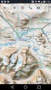
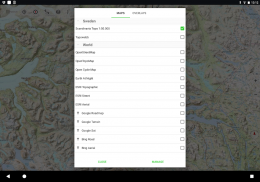
• 지형도 1 : 산 음영이있는 스칸디나비아 (덴마크, 노르웨이, 스웨덴 및 핀란드)의 경우 50,000입니다. 란 테마 테리에 지형지도 + 마운틴지도
• Topowebb : 스웨덴의 Lantmateriet 지형도
• OpenStreetMaps :이 크라우드 소싱 맵은 다른 맵 레이어에 매우 유용한 추가 기능이며 많은 고유 한 기능을 포함합니다
• OpenCycleMaps :이 맵은 자전거 타기 계획에 적합합니다 (PRO 사용자 만 해당).
• ESRI 지형
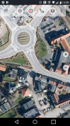
• ESRI 항공 사진
• ESRI 로드맵
• Google 로드맵 (온라인 액세스 전용)
• Google 위성 이미지 (온라인 액세스 전용)
• Google 지형지도 (온라인 액세스 전용)
• Bing 로드맵 (온라인 액세스 전용)
• Bing 위성 이미지 (온라인 액세스 전용)
• 밤에 지구
• 암석 오버레이
실외용 내비게이션의 주요 기능 :
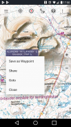
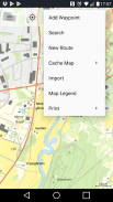
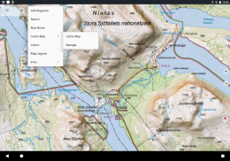
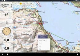
• 웨이 포인트 생성 및 편집
• 웨이 포인트 내비게이션으로 이동
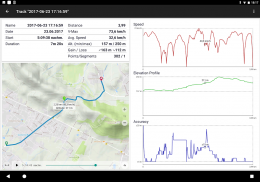
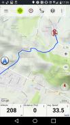
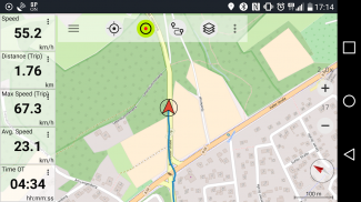
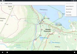
• 트랙 기록 (속도, 고도 및 정확도 프로파일)
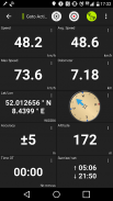
• 거리 측정기, 평균 속도, 베어링, 높이 등의 필드가있는 Tripmaster)
• GPX / KML / KMZ 수출
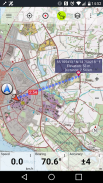
• 검색 (장소 이름, POI, 도로)
•지도보기 및 Tripmaster에서 사용자 정의 가능한 데이터 필드 (예 : 속도, 거리, 나침반 ...)
• 웨이 포인트, 트랙 또는 경로 공유 (이메일, Whatsapp, Dropbox, Facebook 등을 통해)
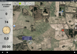
• 위도 / 경도, UTM 또는 MGRS / USNG (군사 기준 시스템 / 미국 국가 네트워크)의 좌표보기
• 통계 및 고도 프로필로 트랙을 기록하고 공유
•지도 회전 (트랙 및 트랙)
•지도를 길게 클릭하여 고도와 거리를 얻습니다.
• 트랙 재생
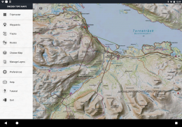
• 맞춤형지도 서버 추가
• 그리고 훨씬 더 ...
PRO에서 사용 가능 : (앱 내 구매에 사용할 수있는 Pro 기능)
• 오프라인 사용-모바일 서비스가 필요하지 않습니다. 로밍 요금이 없습니다!
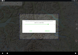
• 오프라인 사용을위한 쉽고 빠른 대량지도 다운로드 (Google 및 Bing지도에는 적용되지 않음)
• 경로 생성 및 편집
• 경로 탐색 (지점 간 탐색)
• GPX / KML / KMZ 가져 오기 / 내보내기
• 웨이 포인트 및 트랙 무제한
• 다른 맵 서버 추가
• 광고 없음
오프라인 사용 :
표시된 모든지도 상자는 캐시에 보관됩니다. 넓은 영역을 캐시하려면 Pro 기능을 구입해야합니다.
하이킹, 자전거 타기, 캠핑, 등산, 승마, 스키, 카약, 사냥, 오프로드 4WD 투어 또는 해양 구조 (SAR)와 같은 야외 활동 에이 탐색 앱을 사용하십시오.
WGS84 날짜와 함께 경도 / 위도, UTM 또는 MGRS / USNG 형식으로 사용자 정의 웨이 포인트를 추가하십시오.
GPX 또는 Google 어스 KML / KMZ 형식으로 GPS 웨이 포인트 / 트랙 / 경로 가져 오기 / 내보내기 / 공유
모바일 서비스 범위가없는 지역 (Pro 기능)에 대한 무료지도 데이터를 사전로드합니다.
의견과 요청은 swedenmaps@atlogis.com으로 전송됩니다
다른 야외 내비게이션 앱을 살펴보십시오.
https://play.google.com/store/search?q=atlogis
++ 우리는 사용자 활동을 추적하거나 사용자 데이터를 수집하지 않습니다! ++
Sverige Topo Kartan - 버전 7.5.1
(21-12-2024)
Sverige Topo Kartan - APK 정보
APK 버전: 7.5.1패키지: com.atlogis.swedenSverige Topo Kartan의 최신 버전
다른 버전들


동일 카테고리의 앱


